Course Maps
Printable Maps and Links
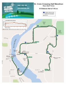
Link to MapMyRun – Half Marathon
Link to MapMyRun – 10K
Link to MapMyRun – 5K
NOTE: Here’s a funny thing… when calculating the elevation on MapMyRun, it isn’t recognizing the St. Croix Crossing Bridge. So, it looks like you’re diving to the bottom of the river. Rest easy… the bridge is a gradual decline to the Minnesota side of the St. Croix River. *Phew*
Course Video
(Provided by ActiveTrack)
Spectator Observation Locations (noted on map)
Half Marathon:
County E and Pine View Trail, Wisconsin – park east of Pine View Trail.
Runners approach from west running east on north shoulder of Wisc. Cty E
https://goo.gl/maps/smsRTt4RbPUAWZoW9
30th St. and Andersen Scout Camp Trail, Wisconsin – park on 30th St., north of Andersen Scout Camp Tr.
Runners approach from east running west in cones on north shoulder of the road
https://goo.gl/maps/fdvmiFgimMWuSCCY9
Half Marathon and 10K:
St. Croix Crossing Loop Trail – Hilltop Trailhead, Wisconsin – park in the parking lot ONLY. This location is also accessible from the finish line area in downtown Stillwater by walking east across the Lift Bridge (pedestrians and bikes only) to the trailhead at the top of the hill – approximately 1-mile or 23 minutes. Please note, this is an 8 percent grade.
Runners approach from north heading south in cones on the west side of road
https://goo.gl/maps/2EmxdV5mVtpCJ3Un6
St. Croix Crossing Loop Trail – Blue Star Trailhead, Wisconsin – park in parking lot ONLY.
Runners traverse the park west to east on the trail before heading through the tunnel under County E/WI35
https://goo.gl/maps/2EmxdV5mVtpCJ3Un6
Half Marathon, 10K, 5K:
Trailhead at MN95 and Sunnyside Marina, Minnesota – park in parking lot ONLY.
Runners approach from south heading north on the Loop trail